Groundwater, Engineering, Environmental & Mining
![]() Hasbrouck
Geophysics, Inc.
Hasbrouck
Geophysics, Inc.
![]()
Groundwater, Engineering, Environmental &
Mining
Contaminant Pathway (Shallow 3D Reflection Seismic)
Three-dimensional (3D) reflection seismic data were acquired at the U.S. Department of Energy (DOE) Savannah River Site (SRS) as part of a 3-year project sponsored by the DOE Office of Technology Development to investigate the use of three-dimensional, three-component (3D/3C) reflection seismic data to define near-surface structures and properties that control groundwater flow and contaminant transport. The data were acquired with available instrumentation; processed with existing, adapted, or developed computer software; and interpreted with a combination of existing and developed methodologies.
The Late Cretaceous and Tertiary age Coastal Plains sediments that underlie SRS consist of numerous aquifers that include sands, sandstones, silts, gravels, and calcareous deposits separated by laminated clay hydrogeologic confining units. At the survey site, the primary confining units are the Tan Clay (2 m thick), the Green Clay (0.5 m thick), and the Ellenton Clay (60 m thick) at approximate depths of 20, 41, and 64 m, respectively. The location, structure, and stratigraphy of these confining units can be mapped with the 3D seismic technology, enabling a crucial understanding of preferential pathways for contaminant transport.
Figure 1 presents a graphical representation of reflection midpoints and the subsequent subsurface coverage of the 3D method. Seismic energy was generated at 13 source points along line A and received by 24 geophones along line C. In an area of relatively flat dip (as at SRS), the midpoint between the source and receiver is taken as the subsurface reflection point. Reflection midpoints for geophone numbers 1 and 24 and sources 1 through 13 are highlighted. The shaded area in Figure 1 represents the total subsurface coverage of all 13 sources and 24 geophones. A section line comprising any combination of sources and receivers can be displayed and interpreted. Thus, 3D seismic surveys allow investigation of an area when access may be restricted. For example, portions of the shaded subsurface coverage area may have restricted access because of high contamination levels, but 3D seismic data can still be acquired for interpretation from within that restricted area.
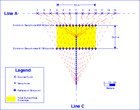
Figure 1: Three-dimensional reflection seismic coverage (yellow shaded area). Reflection midpoints are highlighted for geophone numbers 1 and 24 and for sources 1 through 13. Section lines comprising any combination of sources and receivers can be displayed and interpreted.
Compressional-wave (P-wave) and shear-wave seismic time sections for common geophone midpoints 4 through 15 were converted to depth by applying velocities and static corrections, and the predominant reflectors were digitized. Figure 2 presents a 3D representation of the P-wave reflectors. Geologic horizons corresponding to a calcareous sandstone layer, the Green Clay, and the Ellenton Clay were interpreted using synthetic seismograms and depths from drilling logs for surrounding boreholes. Each one of these geologic horizons acts as an aquiclude in the survey area. Note that the upper two reflectors are absent in relatively large areas, while the lower reflection is also absent in one localized area. The interpreted topography and the presence or absence of geologic horizons indicate possible pathways for contaminants. For example, a contaminant above the calcareous sandstone layer could conceivably migrate down through the Green Clay and the Ellenton Clay aquicludes into the underlying aquifer.
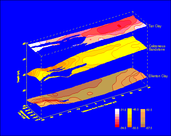
Figure 2: P-wave seismic reflectors for a portion of the shaded subsurface coverage area shown in Figure 1. The varied topography and presence or absence of interpreted geologic horizons indicate possible pathways for contaminants. For example, a contaminant above the calcareous sandstone layer could conceivably migrate down through the Green Clay and Ellenton Clay aquicludes into the underlying Congaree aquifer.
References:
Hasbrouck, J.C., O.A. Dickenson, T.M. Boyd, and W.P. Hasbrouck, April 1996. 3D/3C Seismic Baseline Seismic Technology Report, Technical Task Plan No. AL9-4-10-01, 3D/3C Seismic for Site Characterization, U.S. Department of Energy, Grand Junction Projects Office, Grand Junction, Colorado.
Hasbrouck, J.C., T.M. Boyd, and W.P. Hasbrouck, December 1994. Baseline Seismic Technology Report, Technical Task Plan No. AL9-4-10-01, 3D/3C Seismic for Site Characterization, U.S. Department of Energy, Grand Junction Projects Office, Grand Junction, Colorado.
Dickenson, O.A., 1995. Mapping of Impediments to Contaminant Flow Using Multicomponent Reflection Seismology at the Savannah River Site, MS Thesis, Colorado School of Mines, Golden, Colorado.
![]()
Hasbrouck Geophysics, Inc.
12 Woodside Drive
Prescott, Arizona 86305
USA
928-778-6320 (Telephone and Fax)
928-925-4424 (Mobile)
jim@hasgeo.com (E-mail)
![]()
![]()
Last Modified: 10 November 2004 @ 15:35