Groundwater, Engineering, Environmental & Mining
![]() Hasbrouck
Geophysics, Inc.
Hasbrouck
Geophysics, Inc.
![]()
Groundwater, Engineering, Environmental &
Mining
Humanitarian Groundwater Supply (CSAMT/MT)
Large portions of an extremely poor nation in the Caribbean are in need of potable water sources. To assist in locating future water wells a geophysical survey was conducted to map geologic stratigraphy and structure and relate those results to possible groundwater occurrences.
A hybrid magnetotellurics geophysical method that measures both natural and transmitted electromagnetic waves is termed Controlled-Source Audio Magnetotellurics / Magnetotellurics (CSAMT/MT). Data for such a method are acquired with a Geometrics StrataGem EH-4 instrument designed to investigate from depths of approximately 10 to 750 meters, or greater, depending upon resistivities within the subsurface and signal quality. The method is often used to find subsurface materials and structures that are good producers of groundwater.
Figure 1 shows the resistivity cross-sections (distances versus elevations) along profiles A through C where the general geology consists of marl (also locally often known as blue clay), limestone, conglomerate and andesite. Station 17 is located on top of a mountain in known limestone and is used as a reference geophysical signature for that formation. Marl and/or conglomerate are mapped on the surface within most of the valley areas. The conglomerate appears to be composed of numerous types of volcanic rocks including andesite. No outcrops of andesite are present within the survey area.
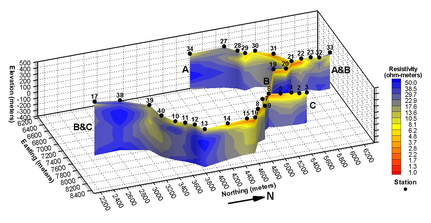
Figure 1: Caribbean Humanitarian Groundwater Supply Project CSAMT/MT (StrataGem) Survey Profiles A, B and C 3D Elevation Sections
Figure 2 shows the profile B cross-section only. Overall the resistivities of the subsurface materials encountered along this and the other profiles are considered low, particularly for the limestone. Very low resistivities for limestone may be caused by a large amount of weathering, inclusion of silts within a highly vugular matrix or perhaps the presence of some salts. Using station 17 atop the mountain as a reference it is interpreted that resistivities above about 15 ohm-meters are representative of limestone, with resistivities greater than approximately 30 ohm-meters interpreted as less weathered or porous limestone. Limestone with resistivities between about 15 and 30 ohm-meters, versus limestone with higher resistivities, may be more water-saturated, more weathered, or contain relatively larger pore spaces perhaps filled with silts. Marl within the project area is interpreted to have resistivities less than about 9 or 10 ohm-meters, while resistivities between about 10 and 15 ohm-meters may be either more competent marl or extremely weathered limestone with considerable silty constituents. The conglomerate in the area is interpreted to have quite low resistivities generally less than about 8 ohm-meters probably because the matrix is either fine-grained material or volcanic material weathered into clay. It is unlikely that anticipated higher resistivity andesite is present beneath any of the profiles to the depths investigated because resistivities only slightly exceed 50 ohm-meters at the most.
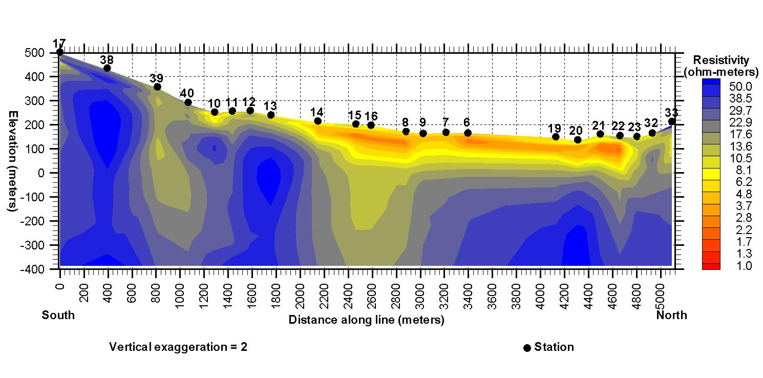
Figure 2: Caribbean Humanitarian Groundwater Supply Project CSAMT/MT (StrataGem) Survey Profile B 2D Elevation Section
Given the results of the geophysical survey, access for a drill truck and a willing landowner, a water well was drilled at a location between stations 13 and 14 along profile B. From the geophysical data it was interpreted that from about station 40 to between stations 13 and 14 water-saturated, more weathered or perhaps silty limestone was present to depths of at least 100 meters. Also, a fault was interpreted to be present just to the south of station 14 beyond which to the north conglomerate and/or marl were present to depths greater than 100 meters.
The water well was drilled to 96 meters depth, verified the geophysical interpretation and produces 600 gallons of water per minute. The well will favorably change this portion of the Caribbean nation forever.
![]()
Hasbrouck Geophysics, Inc.
12 Woodside Drive
Prescott, Arizona 86305
USA
928-778-6320 (Telephone and Fax)
928-925-4424 (Mobile)
jim@hasgeo.com (E-mail)
![]()
![]()
Last Modified: 12 June 2009 @ 15:40