Groundwater, Engineering, Environmental & Mining
![]() Hasbrouck
Geophysics, Inc.
Hasbrouck
Geophysics, Inc.
![]()
Groundwater, Engineering, Environmental &
Mining
Buried Contamint Pit (Shear-Wave Seismic)
Shear-wave seismic surveys were conducted as a part of the Integrated Geophysics Program at the Mixed-Waste Landfill Integrated Demonstration (MWLID) test site, Sandia National Laboratories (Albuquerque, New Mexico, USA), to demonstrate the effectiveness of integrating several surface geophysical techniques to non-intrusively characterize mixed-waste landfill sites (Hasbrouck 1993). The test site was at the Chemical Waste Landfill where the locations of two waste pits (Chromic Acid and Organics Pits) were known from historical records. Although data from numerous profiles were acquired and analyzed, this example is from Line 20E that crosses both known pits.
Seismic wave transmission differences expected between disturbed and undisturbed material can be detected by shear-wave seismic surveys. Variations in the phase, amplitude, frequency, and velocity of horizontally polarized shear-waves are indicative of changes within the subsurface. The locations of these anomalies can be related to pit boundaries and can be used to determine the volume of waste within a particular pit.
Seismic energy was generated by striking a 20-pound (lb) sledgehammer horizontally against a rectangular steel fixture coupled to the ground. The steel fixture had a mass of 90-lb, measured approximately 12 by 20 inches at the base, and was coupled into the ground by eight 8-inch spikes. The relatively large mass of the steel fixture plus the mass of the operator standing on the fixture provided excellent coupling with the ground. The seismic energy was received with uniquely designed two-spike, 40-Hz horizontal geophones (the spikes were located on both ends of the geophone and offered excellent coupling to the ground and reduction of possible spurious vibrations). Field noise analysis tests ('walkaways") were initially conducted and, as a result, data were acquired with the geophones separated 2.5 feet and oriented transverse to the axis of the survey line and with source points located 10 feet from each end of the 24-geophone spread. Two files were recorded at each source point with impacts transverse to the survey line axis and 180 degrees apart. In theory, pure horizontally polarized shear-waves (SH-waves) in an isotropic, homogeneous medium will be 180 degrees out-of-phase when generated by impacts struck in opposite directions. If one of the shear-wave data files is inverted (phase-shifted 180 degrees) then the SH-waves will theoretically be in-phase.
SH-wave data, with moveout removed and one of the data files inverted, are shown in Figure 1. Geophone and station numbers are along the ordinates with time along the abscissas. The indicated interpreted location of the pit (which corresponds to the Organics Pit) was determined from analyses of all the seismic attributes through programs developed within the MATLAB computer package. However, velocity and magnitude anomalies are the most striking and are essentially evident from visual inspection only. A delay of greater than 30 ms, which corresponds to a lower velocity, is evident within the interpreted pit. A significant decrease in magnitude is present beyond the interpreted pit boundary and is indicative of the response expected from a barren area.
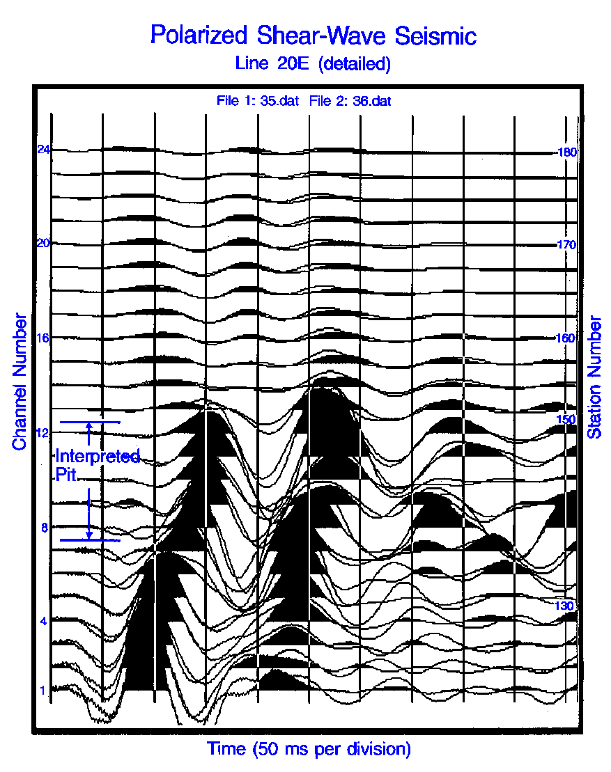
Figure 1: Line 20E, interpreted, horizontally polarized shear-wave
(SH-wave) data
Reference:
Hasbrouck, J.C., 1993. Final Report, TTP AL921102, An Integrated Geophysics Program for Non-Intrusive Characterization of Mixed-Waste Landfill Sites, GJPO-GP-7, U.S. Department of Energy, Grand Junction Projects Office, Grand Junction, Colorado.
![]()
Hasbrouck Geophysics, Inc.
12 Woodside Drive
Prescott, Arizona 86305
USA
928-778-6320 (Telephone and Fax)
928-925-4424 (Mobile)
jim@hasgeo.com (E-mail)
![]()
![]()
Last Modified: 10 November 2004 @ 15:35